
Building Futures (BF) is about identifying projects, ideas, and innovations that create lasting, positive change within the building industry and the communities it serves.
Throughout my professional career, most building projects have relied on the assumption that a functioning “grid” of power, water, sewer, telecommunications, transportation, and internet systems was readily available. Yet, for far too long, these essential networks have been neglected, undermaintained, and rarely replaced when they’ve exceeded their design life. Driving through Chicago in recent years has been both frustrating—because of congestion—and exciting, as major infrastructure renewal is finally visible across highways, rail lines, bridges, and data centers.
This BF explores how watersheds function across North America—focusing on how they shape and support the water flow throughout the Chicago metropolitan area.
Understanding the Watershed
A watershed (or drainage basin) is the land area that collects and channels rainfall, snowmelt, and runoff into a single body of water—such as a lake, river, sea, or ocean.
Chicago occupies a unique hydrological position, the result of one of the most significant engineering feats of the early 20th century: the reversal of the Chicago River in 1900. At that time, the river flowed into Lake Michigan, Chicago’s main source of drinking water, and was heavily polluted, making people sick. Reversing the river’s flow diverted contaminated water away from the lake, protecting the city’s water supply.
Today, this achievement means Chicago is served by two major watersheds:
- The Great Lakes Watershed
- The Gulf of Mexico Watershed
The Great Lakes Watershed
The Great Lakes watershed is truly one of nature’s wonders. A few years ago, while visiting Niagara Falls after a family wedding in Buffalo, I was reminded that Niagara Falls is the primary outlet for water from four of the five Great Lakes—Superior, Michigan, Huron, and Erie.
From there, water travels through the Niagara River into Lake Ontario, down the St. Lawrence River, and finally into the Gulf of St. Lawrence and the Atlantic Ocean.
The Gulf of Mexico Watershed
When engineers reversed the Chicago and Calumet Rivers, water that once flowed into Lake Michigan was redirected toward the Mississippi River system, eventually discharging into the Gulf of Mexico.
The north branch of the river merges at Wolf Point with the main stem, then flows into the south branch, through the Chicago Sanitary and Ship Canal (CSSC), and onward to the Des Plaines River, Illinois River, and Mississippi River before reaching the Gulf.
Similarly, the Calumet River now flows through the Cal-Sag Channel, which joins the same path southward.
Understanding these flow patterns is essential for long-term infrastructure planning, particularly for stormwater, sewer, and water management systems. It also helps identify how pollutants travel through interconnected waterways, demonstrating how an environmental spill in Michigan could ultimately affect Canadian waters.
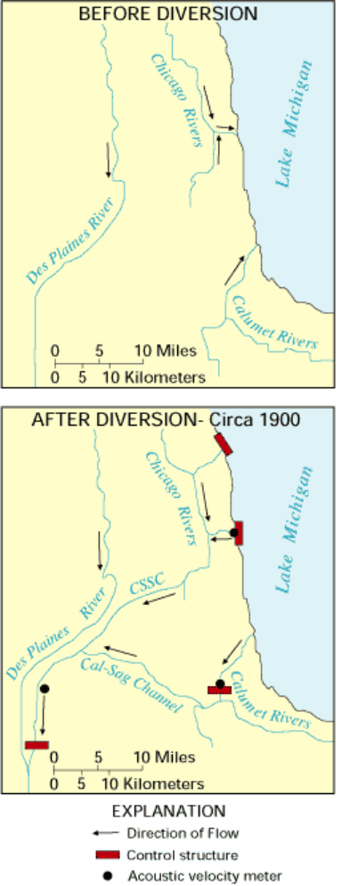
Photo 1: Graphic shows the watersheds that comprise North America.
Photo 2: Shows a portion of the Canadian side of Niagara Falls.
Photo 3: Shows Steve & Lisa on the boat inside the mist created by the Falls
Photo 4: Shows Niagara waterfall from within the water mist.